
Leaving Cloncurry (again!) we knew we couldn’t make it to Gregory Downs via the Burke & Wills Roadhouse before nightfall so spent the night at a free camp by the roadside, in company with about 5 other caravans. We nearly missed it, we couldn’t find the free camp we were looking for but eventually came upon another just as dusk was falling. Another van arrived just after us – they couldn’t find the earlier camp either. Dave has already told (previous blog) of changing a flat tyre here.
Next morning after avoiding some jaywalkers on the highway we arrived at Gregory Downs at the end of the bitumen; from then on it was unsealed to both the Boodjamulla National Park (Lawn Hill) which includes Adels Grove and to Burketown. One dusty motel, one dusty little shop with a fuel pump, a few houses along a dusty side street, and some quite good public toilets …. was that really all?


But just a few hundred metres away was another world, the banks of the Gregory River. As we approached the bridge all we could see was a huge dusty space marked ‘preferred camping ground’ and no caravans at all. Yet we knew this was a favoured stopping spot. All became clear as we went over the bridge – it looked like 50 or more caravans were parked on one side of the river bank below. How to get down? A likely looking track was labelled Stop – No Caravan Access but a passerby assured us it was the way down to the river, everyone went that way. So we went.

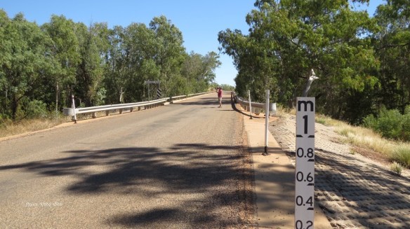
This is the way caravans used to get to the riverside. No wonder a newer ‘driveway’ had become necessary. The day after we arrived a bulldozer blocked off this old bridge with some large rocks.


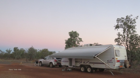
We were soon set up on slightly higher ground than the immediate bank, all places there being taken, under the shade of a large tree. There we stayed for four nights, and even then were reluctant to leave.

We went for several walks including one over the bridge. The very next day a sign appeared – No Pedestrians Permitted on the bridge(!) First the bulldozer then the sign – surely we were not responsible?!


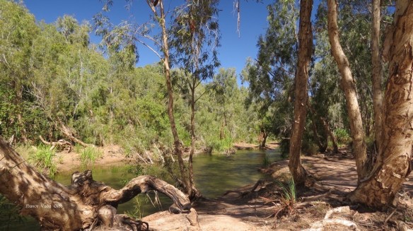
The river at this point was very cool and clear, not very wide and infinitely inviting. We joined a couple of children and adults drifting down the river feet first until fetching up near a small sandbank were it was possible to stand upright again. The pebbles were very sharp underfoot so our elderly feet were pleased we carried our crocs with us while drifting … but thankfully didn’t see any real crocs. No photos of us swimming, alas.


Someone was feeding the kites which swooped and soared above the camp. At one point there must have been 20 or so, the word soon spread. They were being fed with pieces of meat or chicken including fat and bones, thrown as far up as possible. A few adventurous kites would swoop right down to retrieve the pieces that had been missed or dropped. Here are Dave’s photos – the one with a rounded tail is a whistling kite, the others are black kites:


Here’s an outback setup which seems to be very popular … just a smallish trailer which folds up and out and includes a large BBQ, etc. We’ve seen many of these since reaching the outback proper.
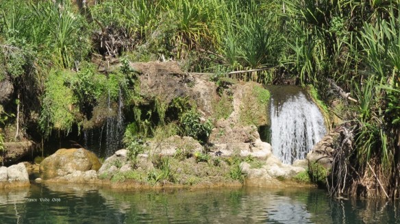
We became friends with two of the nearest neighbours, enjoying pre-prandial drinks and even a small fire on the last night. We marvelled at the fact that the river never runs dry even during summer. And that during the Wet, it can rise over 2 metres in less than an hour! (The photo of the old bridge taken from the new one plus the 1M flood sign will give some idea of just how high the Gregory can rise).
The “small dusty shop” proved surprisingly well stocked. They offered cafe style coffee on a little verandah outside next to a book exchange and clothing rack. Notices everywhere asked for glass jars (I was able to offload several), help with Excel, and apologies because they had run out of coffee beans, so no coffee (!). On our last day there the weekly (?) food truck arrived from Burketown and I was able to get some fresh vegetables and a pot of sour cream (essential for potato salad). A peek inside the covered truck showed a number of large and beautiful potted ferns as well as boxes of food for outlying stations. The spunky young guy driving the truck (why didn’t I have my camera with me) had to write everything down in painstakingly neat figures, so many lemons etc weighting x at y per kilo, total z dollars. I think he stocked up in Burketown but everything came from Cairns probably by huge road train.
We still had a flat tyre to contend with, and the Gregory Downs roadstop couldn’t help, so we left Westy by the river and drove to Adels Grove in the Lawn Hills National Park for the day. Luckily they thought they could fix the puncture there, as indeed proved the case.
A bit of bitumen before the dust started. The distant hills beckoned.


So we were at fabled Adels Grove at last! Named after a French naturalist who established a sort of oasis there, it’s now a business running a holiday park, canoe/kayak hire and solar-powered boat trips up the gorge. Usually you have to book for the latter and initially we were told we’d have to wait two days, but luckily there was a cancellation. Here’s what the gorge looks like from the air.

It was surreal gliding along the Lawn Hill River, no motor discernible, with a knowledgeable guide explaining various features. (This is the boat with the previous load of passengers).


Through the gorge we went, admiring the huge cliffs with ferns and trees clinging precariously……. (the sun was very bright, difficult to take good photos with the deep shade)


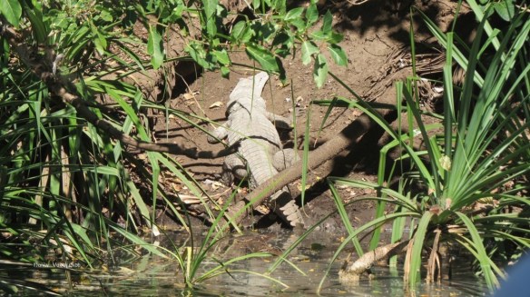
….. spotting a lone croc sunbaking and a couple of Leichhardt trees…..
….. and finally coming to a barrier, the Indarri Falls, formed by calcite concretions called Tufa which had slowly built up over the years. The river is very high in mineral content, much higher than most other rivers. Some people were swimming near this barrier, apparently a fairly safe place compared the rest of the river! It was a very hot day and I quite envied them, but we were relatively cool on the boat under a canopy.


An explanation of tufa, for those scientifically inclined, as gleaned from a series of noticeboards:
Rainwater falling on the Barkly Tableland, a large area of limestone to the SW, soaks into the porous rock. Rainwater combines with carbon dioxide in the soil to form a weak acid which dissolves the limestone. the water now rich in calcite and dolomite flows through aquifers (underground springs) of the Georgina Basin which underlies the tableland. Where the honeycomb-like limestone meets the less-porous sandstone, underground water is forced upwards as springs which fed into the creeks and rivers.
In the creek, as water flows over obstructions such as rocks or debris, a reaction similar to unscrewing the top of a soft drink bottle takes place and carbon dioxid e gas is given off and a skin of solid calcium carbonate (calcite) is deposited on the obstructing surface. With time the calcite forms a porous brittle rock known as Tufa.
As calcite is deposited in the creek, plant and animal matter can be trapped and fossilised within the tufa….. Scientists believe that in ancient times calcite rafts played role in fossil formation.


Back down the gorge to our starting point. Nobody wanted to leave the boat, but another group of passengers was waiting.

Time to move on. We packed up and left the river with regret, heading back the 148 km to the Burke & Wills Roadhouse, then north towards Normanton.

Truly awesome guys, when we think we have got all here in godsown the outback is just as inspirational.
Thanks, Ross.